Oosterschelde
We re-entered at the sluice (lock) into the Oosterschedule. (See last blog entry about our big detour due to bridge closures).
This is a massive man made structure built as a result of the 1953 North Sea Flood. As we will come to understand, The Netherlands land is predominately below sea level and historically suffers terribly from flooding, it’s also very flat (great for bike riding). The country has massive infrastructure controlling water (sea water dams, bridges, locks and aqueducts) and shipping via container ships and barges carrying soil, sand, coal, fuel etc is how almost all of it’s cargo, products and industry is moved around. Anyway back to the Oosterschedule…
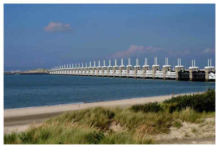
The nine-kilometre-long Oosterscheldekering (kering meaning barrier) was initially designed, and partly built, as a closed dam, but after public protests, huge sluice-gate-type doors were installed in the remaining four kilometres. These doors are normally open, but can be closed under adverse weather conditions. In this way, the saltwater marine life behind the dam is preserved and fishing can continue, while the land behind the dam is safe from the water.
The dam is manually operated but if human control fails, an electronic security system acts as a backup. A Dutch law regulates the conditions under which the dam is allowed to close. The water levels must be at least three metres above regular sea level before the doors can be completely shut. Each sluice gate is closed once a month for testing. Once the test is passed, the shutters are quickly opened again to create a minimum amount of effect on tidal movements and the local marine ecosystem. It takes approximately one hour to close a door. The cost of operation is €17 million per year.
The full dam has been closed twenty-five times since 1986, due to water levels exceeding or being predicted to exceed the three metres. The last time was on 21 October 2014.

RECENT COMMENTS