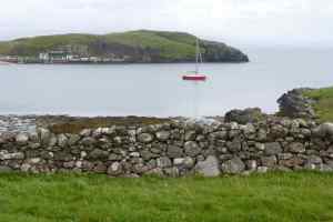
Loch Aline
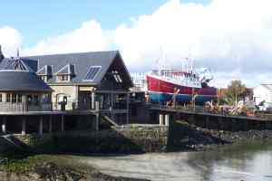
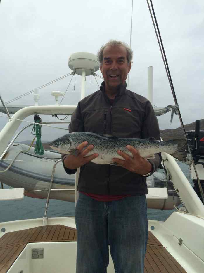
We made the passage around Ardnamurchan point easily after our wait in Mallaig to get the best weather and correct tides. In our Scottish voyage sailing north west before returning south to do the caledonian canal we only had to cover the same piece of water once and that was this small 15 miles back through the Sound of Mull. On the journey N/W we stopped at Tobermory where we met a lovely couple sailing yacht “Aphrodite” with a mooring in Lochaline (also in the sound of Mull – at the other end), and on our return journey they were kind enough to let us overnight here. This time the mooring was easy to identify (unlike Gairloch) as they had their name on it. Scotland still living up to it’s great fishing with a good catch of mackerel brought onboard today, along with a large Pollock (which we confirm we really do not enjoy eating, so won’t be keeping anymore of those we catch).


Mallaig
Keeping with current trends (gales) it seems we were to be in Mallaig the best part of 4-5 days waiting for the correct conditions to passage around Ardnamurchan point, a major tidal gate (and navigation nightmare). Turns out we were not the only ones in this position however as we soon became a small community at the Mallaig Marina with 4 other boats in the same boat! (ha ha ha).

One of these yachts were three people who hired a yacht for 10 days to sail and holiday, and in those ten days had only managed the one sail to Mallaig and were now waiting to sail it back to point of hire – that’s yachting and the weather for you!

Another boat contained Dylan who is very well known in the yachting world as the man behind “Keep Turning Left” sailing blog, website and videos. He single hand sails in his small yacht around the UK posting his experiences – we had read several of his stories previously and of course having the smallest yacht out of the group we (8 of us) all thought it fit to gather on board his boat (5.5 meter long boat, with the cabin being at least a roomy 3 meters) for drinks . . . and yes we did fit and it was a good way of getting to know your neighbours. Huge praise for Dylans posts and he a most entertaining character and tells it like it is, one of my favourites quotes on his web page is …“A good traveler has no fixed plans and is not intent on arriving.” we love that, as we never have fixed plans – maybe a little nervous about the not arriving part tho!

Also in our little collective was Ian “the bird man” whom was the only one in Mallaig for a few weeks not waiting on weather to leave, he was part of an ecological team saving manx shearwaters in the area. Manx Shearwater birds were currently hatching and these birds can’t walk as chicks (so fly and swim only) and when hatching off the cliffs are unfortunately attracted to the artificial lights in the town and end up scattered through the town usually under car’s or in darker corners. Ian and the other volunteers go out each night with a torch and pillow slip and pick up the way-laid chicks and store them in boxes, then the following day take them out to sea on the ferry (the ferry travelling to the isle of Sky) and release them to their proper environment for a take two at fledging to the sea. Great stuff, and of course I would be keen to be in on that, so come 10:30pm off I went to rescue manx shearwaters with Ian, being followed by Dylan and his camera … and of course we only started finding them once Dylan had given up for the evening. The next day Phil proceeded to inform me that manx shearwaters were actually what us Tasmanian’s would call tasting eating mutton birds! Now feeling very guilty as yes growing up I ate many a mutton birds (very greasy and oily but oh so yummy) – also kind of makes sense now as they were always pretty easy to catch as they couldn’t run away. Can I ease my conscious now however that I spent an evening reducing them??
It was also a pleasure to meet David and Francis proprietors of Thistles On Skye B&B (on the nearby Island of Skye) who were next to us on their yacht. After meeting David earlier in the day he asked if we were moored off isle of Ornsay last night – yes that was us…he went on to say he got a phone call from Francis back at the B&B to tell him all about the Red Yacht that she could see out the window from their property – apparently she was very impressed (you have great taste Francis). She came over from Skye later in the day bearing gifts of freshly laid eggs from their hens and a delicious home baked lemon drizzle cake, a fantastic couple with an absolute stunning B&B property with the most fantastic views (check them out here: http://www.thistlesonskye.co.uk).

Mallaig is also the end of the line for the Jacobite steam train famously known as the Hogwarts Express in the Harry Potter Films. Despite the recent fame from Harry Potter it is an amazing train in it’s own right and very much a piece of Scottish History, it’s fabulous that it still runs daily. Described as one of the greatest railway journey’s in the world, (being very picturesque) this 84 mile round trip takes you past a list of impressive extremes. Starting near the highest mountain in Britain, Ben Nevis, it visits Britain’s most westerly mainland railway station, Arisaig; passes close by the deepest freshwater loch in Britain, Loch Morar and the shortest river in Britain, River Morar, finally arriving next to the deepest seawater loch in Europe, Loch Nevis! Whilst we didn’t take a ride, we met it at the station as it arrived and took the required photographs (to look like we rode on it!). Was fantastic to hear it chug into the station and blow it’s steam whistle, and it was certainly full, each day bringing hundreds of people to Mallaig for a couple of hours each day before they made the return journey home.


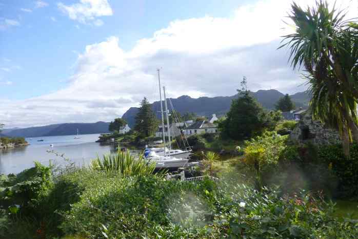
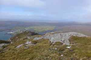
Plockton, Kyleakin, Ornsay & The Biscuit Tin Castle
It is the tail end of the sailing season and again picking our spots to shelter from gales, it seems to be 1 day sailing and 3 days of gale is the current formula. Plockton was todays destination and it was actually a very pleasant sail from Rona with the sun out and win in the sails – turns out it was the best we would have for a while. Plockton was a very sweet inviting bay with a castle on the hill, looking picture postcard perfect when we sailed in as the sun was setting behind it.


One of the first bays we have been to where there was a dedicated anchoring area in a prime position inside the mooring buoys (normally mooring buoys get priority and you anchor outside this area – on the edge where the wind will catch you, just out of the shelter). We cruised by the mooring buoys to check out the price (knowing it was going to blow up the next day) as we had read they were £5 a night but closer inspection on the tags actually revealed £15 per nights so being the thrifty (broke without jobs) sailors that we are dropped the anchor – for free.

Turns out it was another wifi black spot (there are many of these in the UK), meaning we had to have a beer in the local pub to hook into wifi and check the weather – lucky we were on anchor and not paying for a mooring buoy as we could then afford a pint each.
We snuck around the corner (a short 3 miles) to Kyleakin (under the bridge to Island of Sky) to set ourselves up for the next leg through Kyle Rhea which is a sound (or run) which is very tidal and must be taken with the tide or you will be going backwards. On arrival we got that little beep beep indicating wifi signal and after checking the tides, wind and weather and looking at the options for mooring/acnhor in Kyleakin under the bridge where the tide and current was strong, we decided to head back to Plockton for two days to wait out another gale before heading south.


It was also here that we received communications from Australia that we would be getting a visitor from home Nov/Dec! First to come and visit and stay on Red Roo, which also means we have our first ever deadline, needing to be at a certain place on a certain date – well actually more of an aim as we can always catch a train and pick them up and bring them back to wherever we are, but the aim will be to be in London to meet them. Next job finding Red Roo a berth in the River Themes!
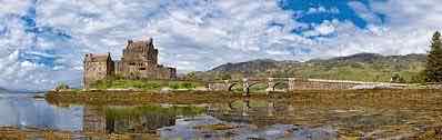
Finally made passage for Ornsay through Kyle Rhea and were even able to time a side passage into Loch Alsh and Loch Duich to see the Biscuit Tin Castle before going through the sound with the tide. Eilean Donan Castle (thirteenth century) is one of the most recognised castles in Scotland, and probably appears on more shortbread tins and calendars than any other, hence it’s nickname – biscuit tin castle.

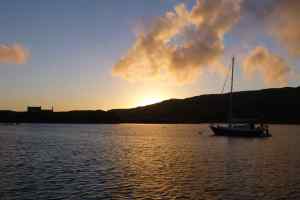
Picked up a mooring buoy in a bay off the Isle of Ornsay, just as the sun was setting (and the wind and waves really starting to whip up). Fees for the morning payable at the pub however after waiting out the gale onboard the entire next day (not safe to launch the dingy to go to the pub and pay), we phoned offering a credit card payment only to be told “that’s fine have those two nights on us – it is rotten weather out there and we don’t envy you rocking around in the boat”. Therefore early the next morning (sparrows fart 05:00) we took off for the short trip into Mallaig before the wind could again gather momentum and ruin the day.

Rona & Loch Gairloch
Loch Gairloch. Weather finally good to leave Stornaway and make our way back down south via a different route before (eventually) transiting the caledonian canal. As we were departing Stornaway a neighbouring yacht offered us the use of his mooring at Loch Gairloch for the night as a stop on our way to Rona Island. Very kind and that would do us just fine (rather than having to pay for a community morning). As we were pulling off the dock we were given very vague directions on how to find it (those instructions being “it’s in the bay – past the island”) and when we arrived at Loch Gairloch later that evening we diligently looked at all the moorings in the bay & then picked the biggest strongest looking one and decided that must be the one he means and made ourselves as home – must have been right as no-one came to bother us.
Rona. Found another home away from home! Could so very easily live here (I know I have said it before and it probably will not be the last time!).

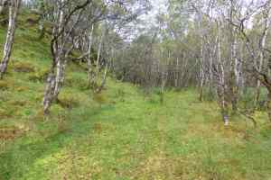
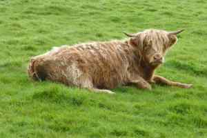
Isle of Rona (the south island with name meaning “rough island”) is 8 kilometres long by 1 kilometre wide it is a perfect size for it’s 2 residents – that’s right two….oh my how I wish it was me! Bill and Lorraine are the caretakers on Rona, they live at Rona Lodge overlooking the harbour and they manage the 3 holiday let cottages on the island as well as all their other ventures running off this… fishing trips for guests, cook what you catch for guests, deer stalking (the island has a deer population) as well as their own venison meat goods from the deer on the island (we certainly enjoyed a version lion, burgers and sausages that we purchases), they also run sheep, chooks and have a fantastic veggie patch.
It is definitely getting towards the end of the sailing season and they were surprised to see us (especially with the poor weather of late), we even got a mention on their blog! https://isleofronalog.com/2016/09/21/my-time-of-year/

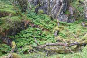
We spent two days on Rona and could have spent many many more. Such a great place to hike, explore and just be. Lots of hills up and down but a new feast for the eyes in breathtaking views around each corner (or over every hill). There is a light house on the northern end of the island but we didn’t make it that far (quite a bush hike and the ground was still very very wet and boggy in places – gumboots got a good work out).


Bill was always keen for a yarn and had great stories to tell (sorry for distracting you from your work in the larder Bill – he was cutting up a deer but we just couldn’t stop chatting). Bill had told us that there was also an English couple on the island staying at one of the cottages that we may run into … later that morning we did just that – we met them on a path near the western bay not too far from their cottage and they were kind enough to invite us into the cottage for a cup of tea, biscuit and chat.


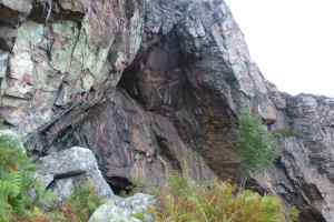
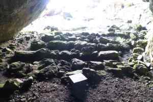
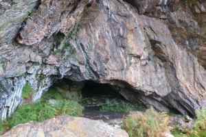
Its hard to believe that back in the 1890’s there were a recorded 181 people living on Rona, by the 1920’s it was down to 14 families then down to 16 people in 1931, by the seventies it was down to three before none in the 90’s and now back up to two + guests. We hiked and found the lost settlements of these communities who were primarily crofters and fishing families. We also found the famous Church Cave on the East side of the island which used to be used for worship until a church was built in 1912.
I can’t recommend this island enough for anyone visiting Scotland get yourself to Rona, web link attached https://isleofrona.com


Stornoway
Well it was a little disappointing that our adventure in the Scottish Hebrides didn’t go anything like our plan. We had intended to spend a couple of weeks on anchor exploring all the little nooks and crannies, lochs & mountains along the east coast (of which there are hundreds), but the weather was pulling rank and reminding us it was boss (and that winter is quickly approaching).
So we are now in Stornaway and have hired a car for two days to drive south and explore via road all the little nooks and crannies along the coast that would make perfect anchoring spots for a yacht – and they were stunning such a shame we couldn’t get Red Roo there – sigh!
The slideshow below highlights what we saw. Including the Calanais Standing Stones (yes more stone circles!), many local statues, harris tweed weaver, black houses, churches and many lovely views.
Loch Maddy
Uninspiring, which was disappointing as I just love the name – reminding me of my old dog back in Australia. The weather was still blowing a gale and not looking like easing anytime soon which is why we had chosen to go to Loch Maddy as it had pontoons (thinking we would be sheltered) but no, there is little (no) shelter just the pontoons which were exposed to winds from every direction and after the swell started to build from winds the pontoons also had a lot of movement bouncing up and down, in fact so much movement the power running to the boat along the pontoons cut out! This helped us make the decision to move on early morning and make a bolt for Stornaway (another great name) on the northern most Isle of Lewis, even though we knew it was going to be a long day out on the water in BIG swell.


Kallin Harbour & Wizards Pool
After the weather eased enough for us to continue north we spent a night on the hook (anchor) in a wee bay named Wizard Pool just north of Loch Boisdale on South Uist, we didn’t get off the boat just an overnight stop and a frustrating time anchoring in the kelp taking 4 goes to set the anchor.
Next stop was Kallin Harbour (North Uist but really more in the middle of Uist island – East Side) the only other real option for safe harbour before leaving the isles of Uist, and again with the weather forecast we knew we were going to be there a couple of days.

We were welcomed by the locals in this wee fishing harbour – they hardly ever see a yacht apparently. It’s rather shallow to get in (we had to wind the centreboard up a little as it was low tide) but once in there is a large concrete quay for the big scallop and fishing boats that call Kallin home as well as a harbour pool for the smaller private fishing boats who were happy for us to raft in with them.

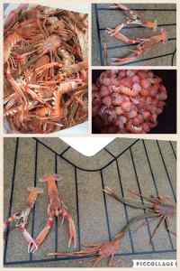
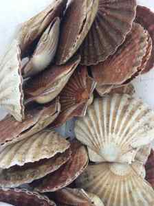
Kallin has a large shell fish processing plant as well as some research and development tanks for some trials on small fish to put into with the salmon farms to eat the parasites. Again “shore fishing” was very productive with Phil bringing home a catch of scallops from a boat unloading its days catch and myself catching a bag of Langoustines (prawns) and Squat Lobsters (small bugs) from a another boat the following day.

Cycling on North Uist.

Loch Boisdale
We made it to the Outer Hebrides 🙂 A great sail with plenty of wind we set a cracking pace, and was made all the better for us by the playful pod of dolphins who travelled with us for a good half an hour splashing at the bow and racing the boat – so much fun!
Loch Boisdale is located on the eastern side of South Uist island in the Hebrides. The Harbour facilities are very new with a massive new breakwater and road as well as a marina complex. This area services the Caledonian McBride ferries to South Uist as well as many fishing companies who have salmon and fish farms in the area. Loch Boisdale itself was very disappointing, not sure you could call it a town, more like a ferry dock with some abandoned buildings that used to be a town, there is a pub that looks big enough to hold a crowd but it really is just a landing stage.
We cycled across to the Western side of the island a lovely easy (no hills) 30 minute cycle to the long stretching beaches with a stunning blue ocean.


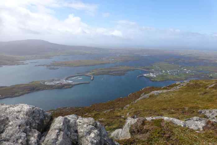
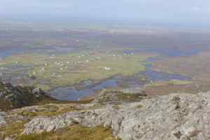
Our second day (we were stuck here for 4 days due to severe winds making sailing out near impossible and very unpleasant) we climbed the hill opposite the marina, and quite a hill it is! A long way around to get started as you have go around the inlet then across a few fields (boggy low lying fields …. equalling wet feet) and then a really steep climb (at times hands and feet in contact with the ground to climb) to get to the top. A couple of stops to shelter from the rain squalls (huddled behind any rocks we could with the wind being so strong the rain seemed to be coming horizontal), as well as a couple of real heart starting frights as grouses flew out of the heather under our feet when we almost stepped on them. The scene unfolding at the top was simply magnificent, we were able to see for miles out to sea back towards the mainland as well as almost all the way across Uist to the western beaches over the low laying land filled with lakes, lochs and bodies of water. The wind up the top was howling and so very strong, having to lean forward when standing up to make sure we were not blown off.
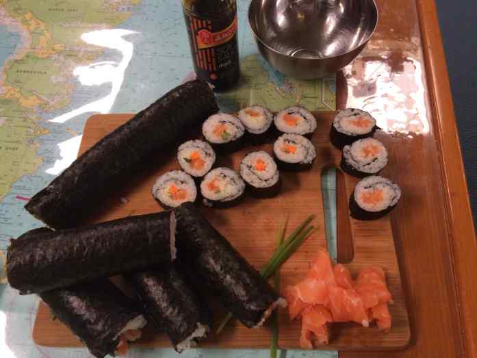
The other highlight from Loch Boisdale was Phil’s efforts at shore fishing (where he gets chatty with local fishermen and gets thrown the odd free fish from the days catch). He certainly excelled here at LB, the first evening a work boat came in that looked a little odd, like a fish farm barge with some large containers on it – turns out it was a fish washing machine, they were sucking the fish up out of the nets and running them through the machine to clean any sea lice etc off them, well the machine was new and they were yet to find the correct settings as on this day they killed a few fish running them through the machine. Disappointing to them I am sure but certainly lucky for us as we were given a huge side of salmon – sashimi, sushi and salmon steaks for us it was. Two days later when we had eaten our way through the first fillets another boat came in and plonked a fish box full of large salmon on the dock, these had been caught from the nets as part of the process they are required to do to catch and examine a certain number each day as a quality check – again lucky us.

Canna

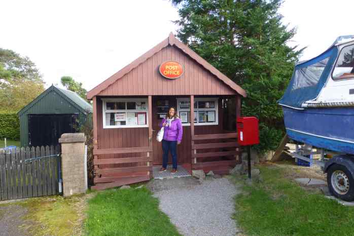
The isle of Canna is a medium size island (7km long and 1.6km wide) with a population of 18. Also connected by a bridge (and sand spit at low tide) is Sanday which is around 1 km long and 1/2 km wide. Although now connected by a road bridge the roads on Sanday are still covered on high tide (beach/rock roads). The island was gifted to the National Trust for Scotland by their previous owner in 1981 and are now ran as a farm and conservation area. There are around 20 buildings on the island including 3 churches, a post office (a converted garden shed), a tea room, a community shop (more about this shortly), a red UK phone box and a primary school with 3 students. Electricity is provided by a diesel generator and it has a private water supply. The roads on the island are not sealed and privately owned so no car taxes are payable by residents.

We very much enjoyed our two nights / one day on the island, for it’s beauty, its peacefulness, and quite a bit of history, in-fact back in 1821 records show that the island was home to a population of over 400 people. Before I forget I must mention the community shop, its a small building but stocking all the essentials (most of it frozen) along with plenty of packet options, as well as the usual chips, chocolates, and a few local crafts and island gifts, the thing that sets this shop apart from any other shop is that it is an honesty shop, that’s right not staffed, but help yourself to what you want, write it in the book (so they can re-stock) and put your money in the tin (calculator provided for those who need some assistance with their arithmetic). How fantastic is that? Fabulous that in this day and age their is still a community built on trust and honesty. There is even an urn with tea, coffee and hot chocolate that you can make yourself and pay for – so a coffee shop also. However it was distressing to read and article on the wall announcing that the shop had been been subject to theft in 2015 extract follows “A tiny community on the remote Hebridean island of Canna is in turmoil after what appears to be its first recorded incidence of crime in years. The island’s community shop, which sells gifts, crafts and groceries and is staffed by volunteers, was ransacked on Friday night. The building is usually left unlocked overnight to allow fishermen to use its free Wi-Fi and to buy what they need while resting at the pier overnight. Payment is made via an honesty box, and shoppers are asked to make a note of what they have taken in a ledger. The apparently peckish thieves cleared the shelves of sweets, chocolate bars and biscuits, as well as six hand-knitted Canna wool hats made by the shop manager, Julie McCabe. …The island has for many years had a crime rate of zero, with reports suggesting the last theft committed on Canna was that of a carved wooden plate from one of the island’s three churches in the 1960s. The plate was never recovered and the case was never solved.”
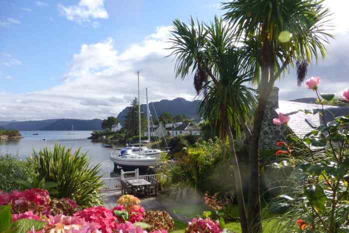
The bay we were moored in was very protected and tranquil, it seems to be a popular stopping point for yachts as we were alone when we stopped mid afternoon but by sunset that evening the bay was full and the same again the next night. Many not going to shore just stopping for the night before heading off early the next morning making the most of the sheltered bay & lovely views. On our second evening we were pleasantly surprised to watch a yacht come in and stop flying an Australian Flag! Was lovely to chat with some fellow Aussies sailing Diomedea whom were spending their season sailing in Scotland before returning to Australia, they were kind enough to take a picture of Red Roo from their boat at sunset and email it to us (included at top of post).

Tobermory
What a wonderful scene, it just makes you smile!

Bright, fun and full of colour this waterfront village on the Isle of Mull, and from boat in the anchorage we had the best view.
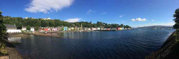


With the sun shining it was easy to sit, look and enjoy.
 We also spotted a Kookaburra in the water, as well as the smallest boat I have ever seen! It was like a Mr Bean boat, so tiny, so cute!
 Strolling along the waterfront streets that evening also got me a wee bit excited as I spotted my first genuine Scotsman wearing a kilt! Follow him we did and ended up in a pub with a lot of other men (and ladies) wearing kilts also. It was the local choir and it was their practice night – at the pub! A pint and a song or 3 were to be enjoyed. The men looked dashing in the kilts whereas the ladies not so much as theirs are long and go to the ankles which in my opinion were not so flattering.
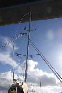
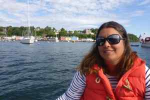
 Also after feeling a slight vibration when under engine whilst coming into Tobermory the Captain sent the crew into the water to inspect the propeller, and then give it a clean to get the mollusks off it – and bingo no more vibration. He asked me to pose for a picture, but failed to tell me about the big yucky jelly fish beside me in the water! And yes, it was very cold, hence the fleece lined sharkskin suit.


RECENT COMMENTS